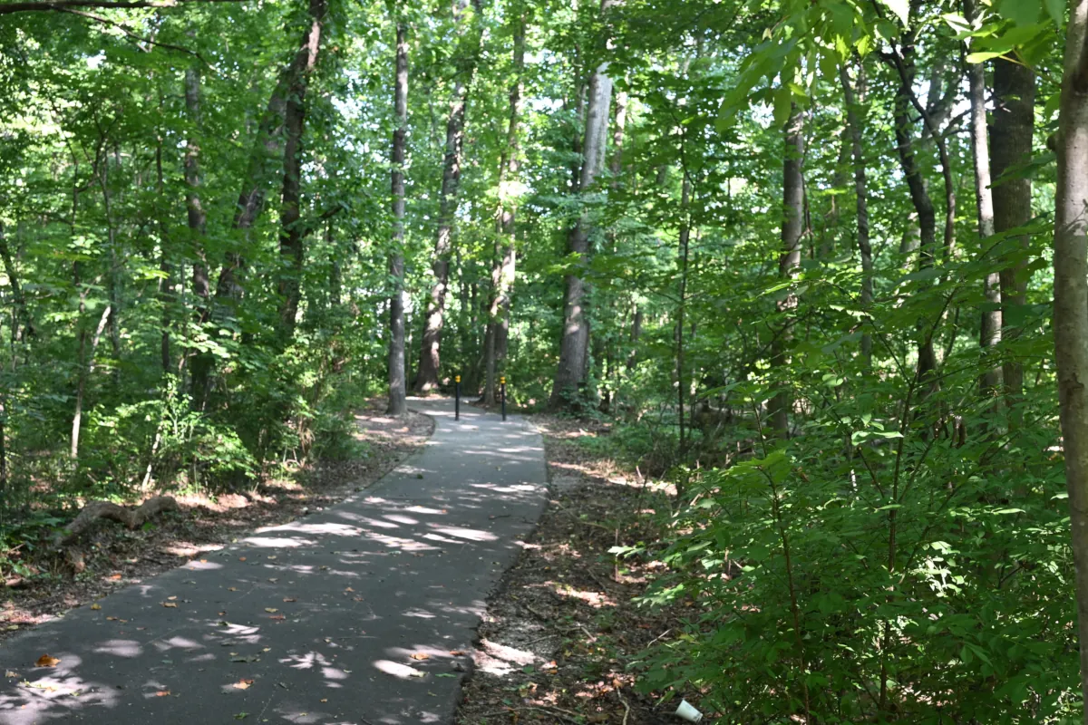
The Ultimate Guide to Greenway Trails in Farragut, TN | Part 2
Central Farragut, School Access and Neighborhood Connections
Walking to Farragut Schools: Can Students Use the Greenway Network?
Quick Answer
Yes. Students living in portions of Central Farragut have access to sidewalks and Neighborhood Connectors leading toward the Farragut Intermediate, Middle, and High School campuses. The most practical daily walking routes generally begin within approximately one-half mile of the Sonja Drive school connector.
However, these are not uniformly continuous, off-road routes. Depending on the starting point, a trip may include neighborhood streets, sidewalks, paved connectors, hills, street crossings, and a 24-step entrance descending from Sonja Drive. Cycling is possible along portions of the network, but the steps and steeper grades mean it should not be described as a seamless bicycle route.
Several additional neighborhoods are physically connected with the broader pedestrian network, but a route that is technically walkable may not be practical as an everyday school commute. Distance, weather, student age, sidewalk continuity, terrain, and each household’s comfort with the route all matter.
This guide examines what the Central Farragut routes actually involve—not simply how close a home appears to the school campuses on a map.
From the Trail Network to the Actual School Routes
Part 1 introduced the two-tier framework used throughout this series: the longer named routes described as Main Greenways and the shorter Neighborhood Connectors that link subdivisions with sidewalks, schools, parks, other neighborhoods, and portions of the broader trail system. Some Neighborhood Connectors also function as Feeder Trails by carrying users toward a Main Greenway or another part of the network.
Part 2 applies that framework to Central Farragut’s school connectivity. It follows the routes at ground level, identifies where sidewalks and connectors meet, and explains why some nearby homes offer a genuinely practical school walk while other technically connected locations are better understood as recreational or neighborhood-walking routes.
Start with Part 1: The Ultimate Guide to Greenway Trails in Farragut, TN →
Why Farragut’s Greenway Names Can Be Confusing
Farragut’s greenway names do not always correspond with the destinations residents associate with them. The clearest example is Turkey Creek.
The Turkey Creek Greenway follows the Turkey Creek Road and Anchor Park area. Despite its name, it is not the principal named greenway running through the commercial district most residents call Turkey Creek. The Parkside Greenway is more closely associated with that shopping corridor.
The routes become even easier to confuse when subdivisions, restaurants, sidewalks, and street crossings enter the picture. Sailview and Brixworth connect with the Turkey Creek Greenway, while Mellow Mushroom is near the Grigsby Chapel Greenway. Cross Campbell Station Road from that general area, and the pedestrian network continues toward the Parkside Greenway corridor.
That does not mean the Town’s trail names are incorrect. Each name identifies a particular geographic segment—not necessarily the complete journey someone assembles from several segments. A practical trip may combine a Main Greenway, a Neighborhood Connector, a sidewalk, a street crossing, and another named greenway.
This is one reason distance alone can be misleading. To understand where a route actually leads, you must identify where each named segment ends, how the next connection begins, and what portion of the journey takes place on neighborhood streets or sidewalks.
The Sonja Drive School-Campus Connector
The Sonja Drive school connector is the principal neighborhood approach to the Farragut Intermediate, Middle, and High School campus area from this portion of Central Farragut.
At its Sonja Drive entrance, 24 steps connect the paved trail below with the roadway above. A narrow path runs beside the steps, although its intended use is not marked. After climbing the steps, pedestrians use a white-lined crosswalk to reach the Sonja Drive sidewalk on the opposite side of the road.
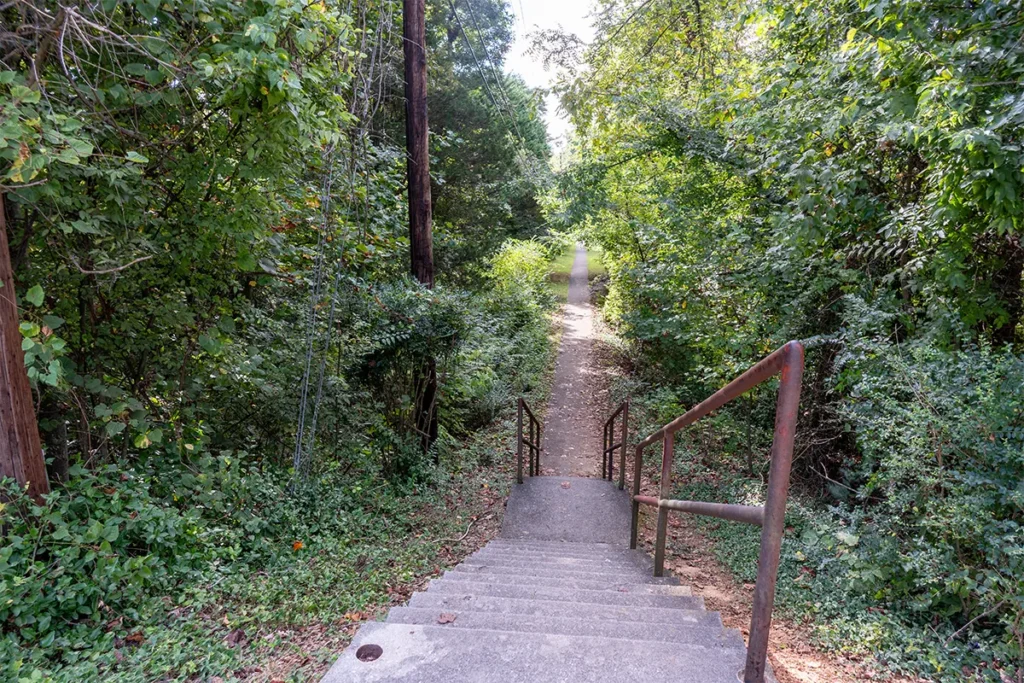
From the bottom of the steps, the paved connector continues through the wooded corridor and enters the campus through a gate behind Farragut High School.
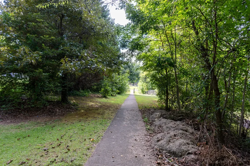
The steps and road crossing mean this is not a completely uninterrupted sidewalk route. Cyclists may also need to dismount and guide their bicycles through this section.
From the intersection of Sonja Drive and Admiral Road, the distance to the top of the school connector is approximately one-half mile. Pedestrians can follow the continuous Sonja Drive sidewalk to the marked crosswalk, cross the road and descend the steps to the connector, creating one of the most direct school-walking routes covered in this guide.
The situation changes east of Admiral Road, where the Sonja Drive sidewalk ends. Homes in that direction may remain geographically close to the campuses, but the absence of a continuous sidewalk makes the practicality of walking more dependent on the specific starting point and the household’s comfort with the route.
The connector also functions as an informal final approach to campus. During the morning arrival period, occasional vehicles approach from both directions and briefly stop near the crosswalk at the top of the steps. That activity is generally spread across approximately 30 minutes and has not created a regular traffic backup in my experience. I have not confirmed whether this is an officially designated student drop-off or pickup location, so I describe it as an observed practice rather than an endorsed school procedure.
For buyers, the practical lesson is simple: being near Sonja Drive is not enough. The side of Admiral Road, proximity to the continuous sidewalk and crosswalk, distance from the 24-step entrance, and comfort with the route all affect whether walking to school is realistic as a daily routine.
Three Levels of School-Route Connectivity
A route can be physically walkable without being a realistic daily school commute. In Central Farragut, school connectivity is best understood at three practical levels.
1. Routes With the Most Direct School Access
The strongest everyday walking routes generally begin within approximately one-half mile of the Sonja Drive school connector and provide reasonably direct access to the continuous sidewalk between Admiral Road and the connector entrance.
This includes the portion of Farragut View along Sonja Drive between Campbell Station Road and Admiral Road. The sidewalk forms the crossbar of a T-shaped pedestrian route. The school connector branches from Sonja Drive between those two points, forming the stem leading toward the Farragut Intermediate, Middle, and High School campuses.
Students approaching from this area can follow the sidewalk toward the school connector, cross Sonja Drive at the white-lined crosswalk, and descend the 24 steps toward the campus area.
For households in this immediate zone, walking may be a realistic part of the normal school routine, depending on the student’s age, the weather, and the household’s comfort with the road crossing and steps.
2. Routes With Additional Distance or Obstacles
Other homes and neighborhoods are physically connected to the same pedestrian network, but the route may involve a longer distance, a steep hill, additional street crossings, gaps in sidewalk coverage, or a combination of neighborhood streets and connector trails.
Cottage Creek is one example.
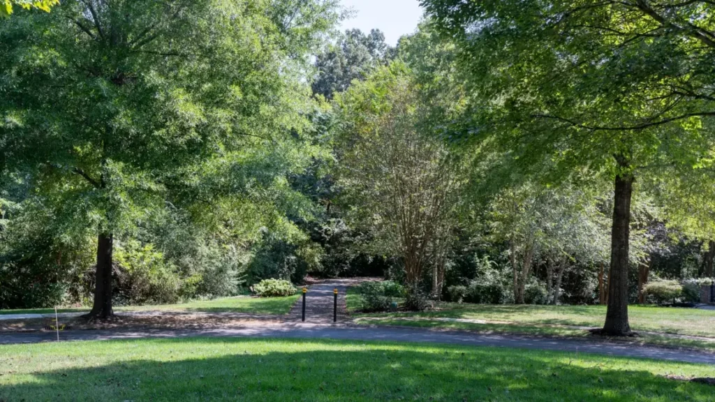
Its paved trail reaches Campbell Station Road beside the assisted-living property.
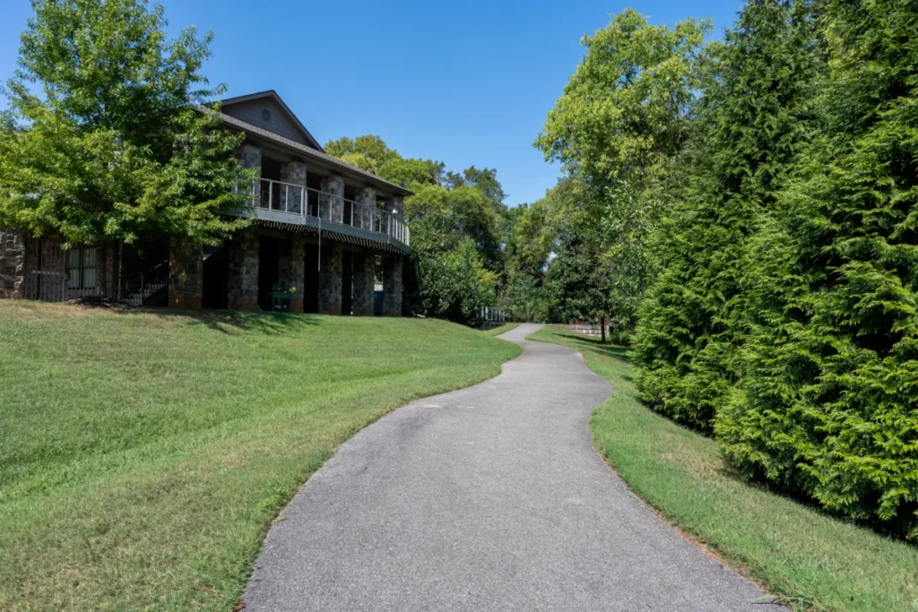
From there, pedestrians can continue along the Campbell Station Road and Sonja Drive sidewalks toward the school connector. The mapped route is approximately 0.6 mile from the Cottage Creek trail area to the connector, but whether it works as an everyday school walk will depend on the household’s exact location, the student’s age, weather conditions, and the household’s comfort with the route.
Portions of Woodland Trace may also fall within the potentially practical school-walking range. The neighborhood entrance is on Sonja Drive near Campbell Station Road, allowing residents to reach the Sonja Drive sidewalk and follow it toward the school connector. Woodland Trace does not have sidewalks, so the first portion of the trip requires walking along its curbed residential streets. I have walked these streets regularly and personally feel comfortable using them while facing approaching traffic, although each household should evaluate the route for itself.
The Cove at Turkey Creek, the Farragut subdivision off Parkside Drive, also has a physical route toward the campuses. Its paved connector climbs a fairly steep hill to Farragut View near Admiral Road and Sonja Drive. Although the connection is valuable, the hill, distance, and eventual 24-step entrance make daily school use more situational than it may appear on a map.
3. Longer Routes Better Suited to General Greenway Connectivity
Sweet Briar, the more distant portions of Stonecrest, and portions of Woodland Trace may connect with Central Farragut’s broader pedestrian network, but their established routes are generally better suited to recreational walks, exercise, neighborhood access, and longer recreational outings than to an everyday school commute.
This distinction matters for homebuyers. A neighborhood can offer extensive trail and sidewalk connectivity without every home in that neighborhood providing the same level of practical school access. The specific address—and the complete route from the front door to the campus—matters far more than the subdivision name alone.
How School Access Varies by Neighborhood
The following neighborhood summaries describe the established routes toward the Farragut school campuses. They are not blanket walkability ratings. Conditions can vary substantially within the same subdivision, so the location of an individual home remains important.
Farragut View
Farragut View provides the most direct everyday school-walking route covered in this guide. The continuous sidewalk follows Sonja Drive between Campbell Station Road and Admiral Road. The school connector branches from Sonja Drive between those two points, forming the stem of a T-shaped pedestrian route leading toward the Farragut Intermediate, Middle, and High School campuses.
At the connector entrance, pedestrians cross Sonja Drive at the white-lined crosswalk before descending the 24 steps toward the campus area. Homes closest to this section of Sonja Drive generally offer the most practical access, while the distance increases for homes farther inside the neighborhood.
Cottage Creek
The Cottage Creek Greenway provides a paved route from the neighborhood to Campbell Station Road beside the assisted-living property. From there, pedestrians can continue along the Campbell Station Road sidewalk and then the Sonja Drive sidewalk toward the school connector.
Google Maps places the route from the Cottage Creek trail area to the school connector at approximately 0.6 mile. That makes walking physically possible, but whether it works as an everyday school routine will depend on the household’s location, the student’s age, weather conditions, and the household’s comfort with the route.
The Cottage Creek trail does not connect directly with Woodland Trace as it may appear to do on a map. After walking the full trail and examining the area from both sides, I found no visible or usable connection between them.
Woodland Trace
Woodland Trace enters Sonja Drive near Campbell Station Road, giving residents access to the continuous sidewalk leading toward the school connector.
The neighborhood itself does not have sidewalks. Reaching Sonja Drive requires walking along its curbed residential streets. I have walked these streets regularly and personally feel comfortable using them while facing approaching traffic, although every household should evaluate the route for itself.
Homes in the portion of Woodland Trace backing up to the Cottage Creek Greenway are approximately comparable in distance to the Cottage Creek route. However, I found no visible or usable trail connecting Woodland Trace directly with the Cottage Creek Greenway. Residents must instead travel through the neighborhood to the Sonja Drive entrance.
For that reason, school walkability within Woodland Trace is highly address-specific. Homes closer to the Sonja Drive entrance may have a reasonably direct route, while homes farther inside the neighborhood face a longer street walk before reaching the Sonja Drive sidewalk.
Stonecrest
School walkability in Stonecrest changes considerably by location. Some homes are relatively close to the Sonja Drive school connector, and I have observed students walking from the Stonecrest direction.
However, the continuous Sonja Drive sidewalk ends at Admiral Road. Most Stonecrest homes are located beyond that point, so the final route toward the sidewalk may require travel along neighborhood streets without the same continuous pedestrian infrastructure available in Farragut View.
Stonecrest should therefore be evaluated by the individual address rather than described as uniformly school-walkable.
The Cove at Turkey Creek
The Cove at Turkey Creek—the Farragut subdivision off Parkside Drive—has an established paved connector beginning at the cul-de-sac on Fords Cove Lane. The trail climbs a steep hill and reaches Farragut View near Admiral Road and Sonja Drive. From there, pedestrians can use the Sonja Drive sidewalk to continue toward the school connector.
The route provides genuine physical connectivity, but the hill, overall distance, weather, and 24-step campus entrance make its practicality as a daily school commute dependent on the student and household. Its broader value extends beyond school access because it also connects residents with surrounding neighborhoods, sidewalks, recreation, and the nearby Turkey Creek commercial area.
Sweet Briar
Sweet Briar is connected with Woodland Trace and The Cove at Turkey Creek through the paved connector network. Those connections are useful for neighborhood access, exercise, and recreational walks.
However, reaching the school campuses requires combining the connector system with a longer route through Woodland Trace and along Sonja Drive. For most Sweet Briar households, this is better understood as recreational connectivity than as a practical everyday school commute.
What the Map Does Not Show: Hills, Steps, Heat and Bicycle Access
Mileage alone does not tell the full story of these routes. Terrain, weather, steps, street crossings, and trail surfaces can materially change how practical a walk or bicycle trip feels.
The Steep Connector from The Cove at Turkey Creek
The paved connector from Fords Cove Lane to Farragut View is fairly steep. The climb can provide a strenuous cardiovascular workout, although I regularly observe people of varying ages using the trail.
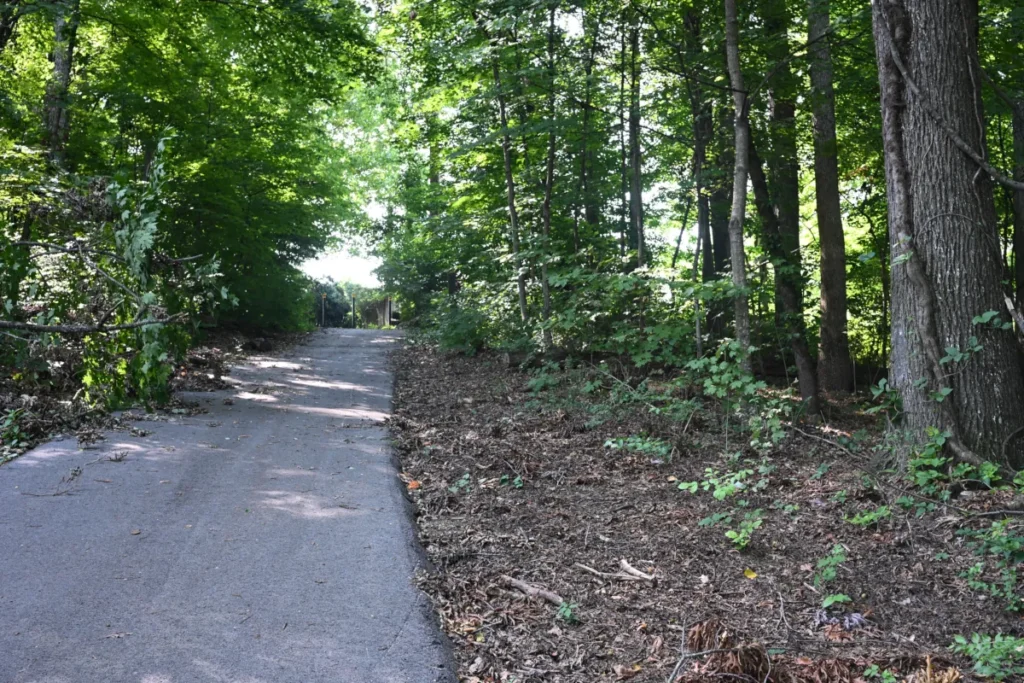
The difficulty becomes more noticeable during hot weather. On summer walks—and even as late as September—I have occasionally rested at the bottom before making the return climb. Anyone unfamiliar with the route should account for the temperature, carry water, and evaluate the hill according to their own fitness and comfort level.
A posted sign at the Fords Cove entrance states: “No motorized vehicles except those approved for ADA use.” I have also observed the connector being used successfully in both directions with a mobility scooter. That observation and the posted exception should not be interpreted as confirmation that every portion of the route meets current ADA accessibility standards.
The 24-Step School Entrance
At Sonja Drive, the school connector reaches the roadway by way of 24 steps. A narrow paved strip runs beside the steps, but its intended purpose is not marked.
After climbing the steps, pedestrians must cross Sonja Drive at the white-lined crosswalk to reach the sidewalk on the opposite side. Anyone approaching from the sidewalk follows this sequence in reverse when traveling toward the campuses.
Bicycle Access Is Possible, but Not Seamless
Bicycles can be used along portions of the Central Farragut network, but the school route should not be described as an uninterrupted bicycle connection. The 24 steps at Sonja Drive create an obvious obstacle, and some riders may need to dismount and guide or carry their bicycles through that section.
The steep connector between The Cove at Turkey Creek and Farragut View may also be challenging for some riders. The practical experience will depend on the bicycle, the rider’s ability, trail conditions, and direction of travel.
Walkable Infrastructure Does Not Eliminate School Traffic
Central Farragut’s sidewalks and Neighborhood Connectors give some students a practical alternative to arriving by car. That does not mean every household uses that alternative.
Knox County Schools places elementary students living within one mile of their school—and middle and high school students living within 1.5 miles—inside the Parent Responsibility Zone, based on the shortest route. Bus or shuttle service is not provided within those zones, and families are responsible for arranging transportation. The policy does not require students to walk.
However, the length of the morning drop-off and afternoon pickup lines at the main campus entrances cannot necessarily be attributed only to families living within the Parent Responsibility Zone. Students outside the zone may also arrive and leave in private vehicles rather than use available bus transportation.
The Sonja Drive connector functions differently from the main campus drop-off areas. During morning arrival, I observe occasional vehicles approaching from both directions and briefly stopping near the crosswalk at the top of the 24-step entrance. That activity is spread across approximately 30 minutes and has not created a regular traffic backup in my experience. On the occasions when I have used this approach because of light rain or a late start, I have generally encountered no wait or only one vehicle ahead of me.
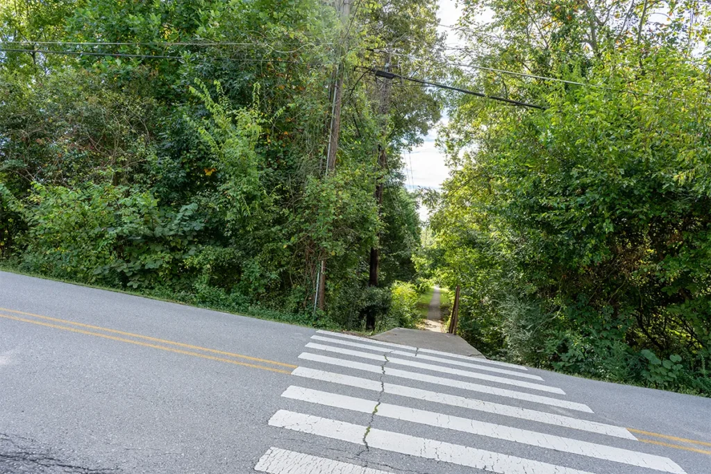
I have not confirmed whether this is an officially designated student drop-off or pickup location, so its use should be described as an observed practice rather than an endorsed school procedure.
The larger traffic congestion occurs in the main campus drop-off and pickup lines. This illustrates an important limit of walkability: infrastructure creates an option, not a behavior. A sidewalk or connector can make walking possible, but weather, distance, student age, household schedules, personal preferences, and comfort with the route ultimately determine whether that option is used.
Follow the Central Farragut Routes on the Interactive Map
The interactive map shows the Neighborhood Connectors, sidewalks, and trail segments discussed in this guide. It can help readers see how Farragut View, The Cove at Turkey Creek, Cottage Creek, Woodland Trace, Stonecrest, and Sweet Briar relate to the Farragut school campuses and the broader greenway network.
The A and B markers identify the approximate endpoints of each mapped route. Select an individual route or marker for a closer look, or open the map full screen to see the complete network more clearly.
Because Google Maps may assign a nearby street address to a trail endpoint automatically, the displayed address should be treated as a geographic reference—not as a public parking location, trailhead designation, or invitation to enter private property. Follow posted signs and remain on established trails, public sidewalks, and public streets.
Open the Interactive Farragut Neighborhood Connector Map Full Screen →
Before Buying a Home Based on School or Greenway Access
Do not rely solely on the subdivision name, straight-line distance, or a route shown on a digital map. Walk the actual route from the home you are considering.
Locate the neighborhood entrance, confirm where sidewalks begin and end, and identify every street crossing, hill, step, and change in trail surface. Follow the route far enough to understand where it actually leads and how it feels under realistic conditions.
For a possible school route, consider walking it near the time a student would normally travel. Traffic volume, visibility, temperature, and activity around the campuses may feel different during morning arrival or afternoon dismissal than they do in the middle of the day.
Also consider whether the route remains practical in hot weather, light rain, or during shorter winter daylight hours. A route that works comfortably for an adult on a pleasant weekend may feel very different as part of a student’s daily routine.
Transportation eligibility should also be confirmed for the specific property. Knox County Schools provides a Bus Stop Locator and explains how its Parent Responsibility Zones affect bus service.
Check the Knox County Schools Bus Stop Locator →
A five-minute Neighborhood Connector can materially change how accessible a school, park, neighboring subdivision, or Main Greenway feels from a particular home. Conversely, two homes in the same subdivision may offer very different levels of practical access. The only reliable way to understand that difference is to evaluate the complete route from the individual property.
Frequently Asked Questions About Walking to Farragut Schools
Can students walk to the Farragut school campuses from nearby neighborhoods?
Yes. Portions of Central Farragut have sidewalks and Neighborhood Connectors leading toward the Farragut Intermediate, Middle, and High School campuses. The most practical daily routes generally begin near the Sonja Drive sidewalk and school connector. Actual suitability depends on the individual address, distance, student’s age, weather, terrain, and the household’s comfort with the route.
Is there a continuous sidewalk from Sonja Drive to the school campuses?
Not completely. The sidewalk follows Sonja Drive between Campbell Station Road and Admiral Road. At the school connector, pedestrians cross Sonja Drive at a white-lined crosswalk and descend 24 steps to the paved trail leading toward the campus area.
Can students ride bicycles on the school connector?
Bicycles can be used on portions of the route, but it is not a seamless bicycle connection. The 24 steps at Sonja Drive may require riders to dismount and guide or carry their bicycles. Steeper grades elsewhere in the connector network may also be challenging for some riders.
Does the Cottage Creek Greenway connect directly with Woodland Trace?
I found no visible or usable direct connection between the Cottage Creek Greenway and Woodland Trace after walking the full route and examining the area from both sides. Cottage Creek reaches Campbell Station Road beside the assisted-living property, while Woodland Trace residents reach Sonja Drive through the neighborhood’s established street entrance.
Is The Cove at Turkey Creek connected with the school campuses?
The Cove at Turkey Creek—the Farragut subdivision off Parkside Drive—has a paved connector from Fords Cove Lane to Farragut View near Admiral Road and Sonja Drive. From there, pedestrians can use the Sonja Drive sidewalk and school connector to continue toward the campuses. The route is physically connected, but the steep hill, distance, weather, and 24-step entrance affect whether it is practical for everyday use.
Is The Cove at Turkey Creek the same place as The Cove at Concord Park?
No. The Cove at Turkey Creek is the Farragut subdivision off Parkside Drive discussed in this guide. The Cove at Concord Park is a Knox County park and recreation area on South Northshore Drive. They are entirely separate locations.
Sources and Field Verification
This guide combines firsthand route verification with publicly available mapping, school transportation information, and municipal resources. I personally walked and photographed the Neighborhood Connectors and pedestrian routes described in this article.
- Town of Farragut Parks & Greenways
- Town of Farragut Greenway Map
- Knox County Schools: Transportation Need to Know and Parent Responsibility Zones
- Knox County Schools Bus Stop Locator
- Knox County Schools Budget and Capital Improvement Plans
- Knox County Parks: The Cove at Concord Park
- Interactive Central Farragut Neighborhood Connector Map
School-campus update: This article documents the existing Farragut school configuration and pedestrian routes as of September 26, 2026. A new elementary school in the Farragut area is expected to open for the 2027–28 school year. As Knox County Schools prepares for the new school, attendance zones and campus assignments may change. The routes described here should therefore be understood as physical connections to the present campus locations rather than guarantees about future school assignments.
Mapped distances are approximate. Trail conditions, access points, signs, sidewalk coverage, transportation policies, and traffic patterns may change. Readers should verify current conditions and follow all posted rules.
Looking for a Home Near Farragut’s Greenways and Schools?
Buying Near the Greenway Network?
A home can appear close to a school, sidewalk, or greenway on a map without offering the kind of access you expect. Hills, steps, missing sidewalk sections, street crossings, and the precise location of a neighborhood entrance can completely change how practical the route feels.
I know these routes because I have walked them—not simply looked at them on a map. If school walkability, greenway access, or the ability to reach nearby parks and shopping without always using a car matters to you, I can help you evaluate the complete route from an individual home.
Search Farragut Homes for Sale →
Selling a Home Near a Neighborhood Connector?
Some Farragut homeowners may live near a valuable connector for years without realizing where it leads. I understand that firsthand: I had lived in my own neighborhood for a year before a next-door neighbor told me about its connector system.
That kind of overlooked detail can matter when presenting a home to buyers. A short path behind a cul-de-sac or at the edge of a subdivision may provide access to another neighborhood, a school route, a park, shopping, or a larger portion of Farragut’s greenway network.
Effective hyperlocal marketing means identifying those connections accurately and explaining their practical value without overstating what they provide. If you are considering selling, I can help uncover the location-specific features that may distinguish your home from others nearby.
See What Your Farragut Home May Be Worth →
Questions about a particular neighborhood or route? Reach out anytime. I’m happy to talk through what greenway and school connectivity actually looks like from an individual Farragut home.
David Hamilton, REALTOR®
Weichert, Realtors – Advantage Plus
Cell: 865-284-HOME
Office: 865-474-7100
Email: david@davidhamilton.com
Coming Soon in Part 3
Parts 1 and 2 focused on Central Farragut’s Neighborhood Connectors, school access, and the pedestrian links between nearby subdivisions.
Coming soon in Part 3: a closer look at the Turkey Creek Greenway, including where it runs, how residents access it, and how it connects with nearby parks, neighborhoods, sidewalks, and other portions of Farragut’s pedestrian network.


2 thoughts on “Walking to Farragut Schools: What Central Neighborhood Routes Actually Involve”